place to construct a water supply well (if
you don’t put it in the floodplain) because
more water will potentially be available to
the well, and it will have a greater yield.
Bottom line: Don’t drill wells on the
hilltops in the Mountains and Piedmont.
You will pay more (well drillers charge by
the foot), and be statistically less likely to
encounter a high yielding well. But this
isn’t true everywhere.
The Sand Hills of North Carolina have
some of the most famous golf courses in
the world. These beautiful hills are actually
the remnants of an ancient beach scarp.
Yes, I know the Sand Hills are almost
100 miles inland, but in times past (about
64 million years ago), the beach was in
Moore, Hoke, and Scotland Counties. The
ocean eventually receded, leaving coarse-
grained beach sands perched atop hard, flat
clays and basement rocks.
The Sand Hills are not supported by a
rock skeleton, but are more like mounds of
coarse sand placed on top of a relatively
impermeable layer. These hilled up mounds
of sand compose the highlands and ridges
of the Sand Hills and make an ideal source
aquifer for public water supply wells.
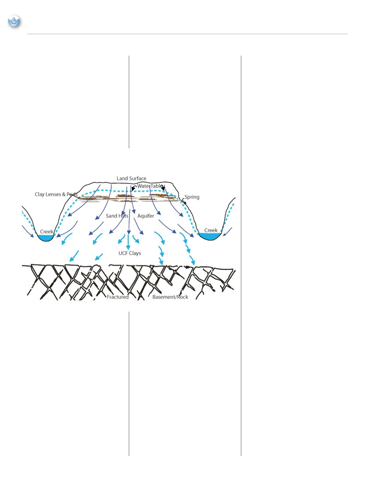
Figure 2 shows an idealized cross-section
of a typical hill in the Sand Hills.
A quick look at the Figure 2 cross-section
shows that the best place to site a well in
the Sand Hills region is directly on the
hilltops. This goes against the logic of
avoiding hills for well locations in the
Mountains and Piedmont. Locating water
supply wells on hilltops in the Sand Hills is
a good idea, as the water table is just below
land surface, and the center of mass of the
available water is directly under the hill.
The Sand Hills aquifer is fairly prolific,
and public water supply wells here average
more than 125 gallons per minute, with an
average depth of less than 200 feet. The
water levels in the wells recover very
quickly after pumping and static water
levels have remained stable, although
some of the public water supply wells are
over 30 years old.
Because the sands hold and transmit a lot
of water, streams in the Sand Hills almost
never go dry. They are continuously
recharged by the influx of groundwater
moving through the aquifer from higher
elevations to areas of lower head. Rainfall
is the source of recharge to the aquifer. The
rain impacts land surface, then percolates
downward to enter the water table, thus
recharging the aquifer.
You can see how important it is to have
a knowledgeable well driller. Since 1998,
the state has required well drillers to be
certified, and this guarantees a minimum
level of knowledge and experience. An
experienced driller knows the local aquifer
conditions and can help make a better
decision on where to locate new water
supply wells.
If you are looking for new well sites or
locations, consult with your well driller.
They often have years of firsthand
knowledge and can put you on to the
location that statistically will have the
highest yield. Keep in mind that a dry hole,
or a low producing well is possible, even
when armed with the best information.
If your system uses groundwater, Rural
Water can assist in protecting your wells.
Our technicians can help you develop
a Wellhead Protection Plan that raises
public awareness of the importance of
best management practices, which can
reduce the chance of a leak or spill.
Chemical spills can percolate downward
and enter the aquifer, and then be drawn
into pumping wells. In the case of the Sand
Hills, spills can be especially troublesome
because the sands of aquifer transmit water
very readily.
If you have questions about Wellhead
Protection, siting a well location, or
geological conditions in your area, give us
a call.
Images used in this article are renditions
of images found on the United States
Geological Survey web site.
20
NCRWA.COM |
Fall 2013
feature
Figure 2.
Groundwater Situation in the Piedmont and Mountains of North Carolina


