Just west of Liberty, the geologic map
showed a diabase dike that runs north-south
for more than 57 miles. Now this problem
has my attention. I have heard an old rumor
that well drillers sometimes target diabase
dikes in the search for water. What is it about
these dikes that can increase the potential of
a high-yield well?
To answer this question, I contacted Rick
Bolich, a geologist with NCDENR who has
a lot of experience in the slate belt and with
diabase dikes. Rick told me that the nearly
vertical tabular dikes can act as a barrier
to groundwater flow in some cases, and
conversely, as a conduit for groundwater
flow in others. Sometimes when molten rock
is injected into the surrounding host rock, it
cracks up after cooling takes place. These
cracks can allow the flow of groundwater and
if suitable, the dikes can be used as a source
of water (Figure 1). This is particularly true in
the clay-rich Triassic Basins of North Carolina.
Rick told NCRWA that the dikes are typically
highly fractured, but the fractures are often
not connected together to allow groundwater
to flow. Another issue with wells drilled
into dikes is water quality; the high iron and
manganese content and hard water make the
water less desirable.
Figure 2 shows that well A is drilled into
a diabase dike which has fewer and smaller
fractures, and acts as a barrier to groundwater
flow into the well and results in low yield.Well
B, on the other hand, is drilled into a rock type
that has more fractures and therefore yields
more water. Because the dikes are injected
into the country rock as high-temperature
molten magma, they can create a bake zone.
The bake zone can fuse the host rock into
an impermeable barrier that will impede
groundwater flow.
Rick told NCRWA that because the dikes have
a high iron content, they can be located using
a magnetometer, and magnetic surveys can
be conducted relatively cheaply. I told Chris
that Liberty may want to contact a college or
university and see about getting a student to
run a survey to pin down the exact location
of the dike. The dike was not evident on the
ground, on topo maps or on the aerial photos.
I noticed that Liberty’s Well 8 was drilled
almost on top of the dike’s location, if the
geologic map is accurate.
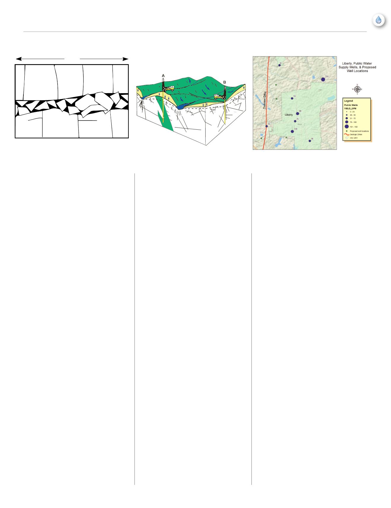
If you look at the yield of nearby wells,
sometimes you can determine patterns or
trends that can help when looking for the ideal
well site, and I wanted to compare Well 8’s
yield to that of nearby wells. Figure 3 shows
the location of Liberty’s wells and some
adjacent public water supply wells. The well
yield is shown with a graduated symbols that
show the size of each well’s yield.
Well 8, drilled near the diabase dike does not
have a higher yield than other wells in the
area. Looking at well yields north and south of
Liberty in the vicinity of the dike, there were
no discernable trends related to the dike’s
location. So much for rumors.
I also looked at the depth of nearby wells to
determine whether there was an optimal depth
at which fractures were encountered during
the drilling process. Once again, this did not
prove very fruitful. There is little correlation
between well depth and well yield in the
area around Liberty. However, I gave Chris
some statistical information that could help in
determining how deep the well should be.
US Geological Survey Water-Supply Paper
2341-A looked at data from more than
5,000 water supply wells constructed in the
Mountains and Piedmont of North Carolina.
I told Chris that statistically, if a borehole
does not encounter water zones within 600-
700 feet below land surface, the chance of
encountering water-producing fractures gets
smaller with depth. This is because the weight
of overlying bedrock prevents larger fractures
and cracks from occurring at depth.
The average yield for wells in the Liberty area
is about 50 gallons per minute, so I told Chris
that he could reasonably expect a 50 gpm
yield for the new well. Also, the location of
the diabase dike west of Town probably had
little effect on groundwater, one way or the
other. A few days later Chris called me with
news that the new well came in with a yield of
43 gallons per minute at about 650 feet depth.
The 24-hour pump test is the next item on the
list of things to do in the Town of Liberty. Chris
will have his plate full for a while in getting
the new well on line, and Rural Water looks
forward to helping him in any way we can.
Winter 2014
|
13
feature
1 meter
Rubble zone and cooling fractures
in extrusive igneous rocks
Why are some wells dry?
Adapted from
Daniel, C.C. III, (1990).
FIGURE 1
FIGURE 2
FIGURE 3


